Tuesday, October 30, 2012

Why I Won't Be Moving Back East Soon

When I started to plan this December tour back East, it might have become a retreat. Between the struggles of being in a new city and facing debt head on, I was beginning to get worn down. The opportunity to work back in Buffalo seemed like a sign, maybe New York is where I belong? Maybe I should take some time off, pull the good ole 20-something move and move back into my parents house and not pay rent.

Flowers and the Hills

But that isn't the case. I was fortunate to get back into the staging industry here (where I wanted to get out of) which pays fairly well out here, so my struggles of money began to dissolve. But money only solves some happiness. The loneliness started to creep in in my new settings, especially once the seasonal work dried up.

Oddly enough being in a city had turned out to be immensely lonelier than being alone on the road. Why? Is it that hope of a destination that staves loneliness? Do greater populations mean greater introversion? Whatever the case may be, I had to find a way to stop stressing. So I did what I did all summer, I rode.

I want to go down that Fire Road.


It began with conquering some of the local hills around here and then I worked my way into climbing Diablo and Tam, but I'm not done yet, and that's the point. Here the new rides just seem endless. Even weekend camping trips or week long tours seem much better than back in NY. I remember struggling to think of where to go on day rides in Buffalo, it seemed every direction had already been taken. And when the roads start to look the same, it's time to move on. Here, it's different. I just keep piling these "have-to" rides and these desired tours starting from my doorstep into a long list of musts. North to Vancouver? Sounds great. South to LA? Beach sounds nice. West to Reno? I didn't like having money much anyway. Being beyond the Rockies or beyond the Plains line, or however you define the West, all I can think of is how great the riding is and there is no desire to go back East. Occasionally I read blogs from Mid-West riders, or some riders back East and see their photos (exceptions made for Appalachia and parts of Western and Northern New England) and want to grab them and tell them, "You'll love it out here!". Because since being here, I'm pretty sure I do.

It almost seems there is no city there, just mountains before the ocean.

Monday, October 29, 2012

Continental Grand Prix Tire

Okay, so this tire is not new for me. I've had it for a while, but have finally reached the breaking point. But before I get too hard into trashing this tire, I'd like to talk about Continental and their reputation first. Before I even really got into cycling "Gatorskin" was the word I had always heard when it came to "bulletproof" tires (which I hate that word, every tire flats). Not only because of their supposed durability, but their smoothness too. This reputation made me alright with replacing my Schwalbe Marathon with a Continental Grand Prix on tour. I would have preferred a Marathon at the time, but would have had to wait for it (hindsight being 20/20 I wish I spent more time places anyway and Boise seemed surprisingly awesome).

It wasn't long for the Continental Grand Prix to prove itself trouble. In Eastern Oregon, on the day labeled "The Day Everything Broke" (pedal, chain, headphones, rack, fender, everything), my Grand Prix was flat after emerging from a diner where I had went to cool my head. It was an added frustration I didn't need. The culprit? Not some huge nail, or giant piece of glass, but rather a tine shard of metal, so small I could barely see it. Well, so much for bulletproof (the next day in the same desert, I got a second similar flat).

This is common when riding the Grand Prix. 

Over time the flats just kept coming, especially once I got into the city and started bombing curbs and hitting potholes (I'm not going to be gentle, it's a touring/cross frame, it's meant to be beaten). The pinch flats were constant. I realized that the Conti tires need to be filled before every ride; that's frankly inconvenient. Once I figured this out the pinch flats started to slow down a little.

Once again though, as soon as I thought, maybe they'll last the tire wears through. Now every time I brake heavy on a descent, the tube gives way thanks to a nice soft spot the tire decided to reveal, this happened both today and yesterday. Sure I put some miles on this, but my Marathon on the rear right now came from Chicago, and it is still going much stronger than the Conti.

Tire is bust.

The one plus side is that the grip never let go on me. Not once did I lose my front tire hitting a bend, so there's that. But then add the fact that Continental customer service is none to be found, (I emailed them, to no return) I would avoid these tires at all cost. Never again. If I am going to find a lighter tire than the Marathons in the future, I'd probably try some Vittorias, but not Continentals. Luckily, Weds I get my Marathon Mondials, so expect a post of those in the coming future. All this means is tomorrow and Weds will be forced rest days, how sad.

Sunday, October 28, 2012

Tam

Tam

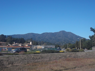
The last day of tour my route took me to the Golden Gate bridge through Marin County, following through Sausalito, Mill Valley, and other quaint little bayside towns just north of San Francisco. But sadly, since then I haven't made it back, until today. With Diablo under my belt I had to find the next challenge, that challenge is Mount Tamalpais, or Tam, as it is amicably referred to by local cyclists. A 2,571 triple summit mountain resting in it's own reserved State Park in Marin County.

But before the ride, some whining. The biggest reason so far why I haven't made it to Tam, or Marin for that matter, is the fact that I cannot ride to San Francisco, to cross the bridge into Marin. Hell, I can't even take the Richmond San Rafeal brdige to the north to get from the East Bay to Marin. It's a problem that thankfully people are working on (the new Bay Bridge to Treasure Island will have a dedicated cycle/ped lane and there was a recent resolution passed to use toll funds to build a way to connect the gap, but not soon enough, they can't just close one lane of traffic to let immense cycle traffic?), but nevertheless it makes getting to SF a rarity for me (this was my first time there since my last day of work over a week ago). So I took the two mile ride down to West Oakland and hopped on BART.

Waiting for BART with Oakland in the background.

I had to hit the library first, so I couldn't take Embarcadero to the Bridge, instead I had to cut through the busy Frisco streets. This is another reason why I'm glad to be an East Bay resident, less urban, less stoplights, less hassle. I stopped and go'd and stopped and go'd, and finally made it to the Golden Gate Bridge. The last time I saw this bridge this close was a foggy late August day, finishing my cross-country tour, but today, I go the other way first.

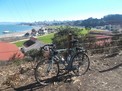
SF skyline from the Presidio.
The bridge.


Why I thought going through Sausalito/Golden Gate on a Sunday was a good idea, I don't know. The tourists on rental bikes clogged the pathways and bridges. I'm glad that these people are renting bikes and getting into it (and I hope they ride bikes at home, a digression I will pass on for now), but man, trying to get a serious ride in while dodging people who hardly know how to ride (or bike path manners!) is tough. I managed the traffic and cut off the bike paths to the climbs.

I somehow found myself turning down this narrow one way street, a horse carriage street, that because of the hill could never be widened. It felt like a bike path, except for the fact that it climbed. Sometimes getting lost can be the best thing possible, I was originally going to take 1, but I am sure glad I found this hidden gem to peacefully climb.

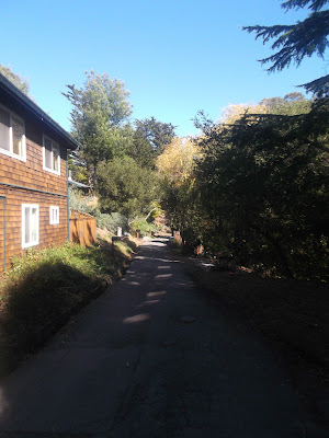
I believe it's called Jane Road? Whatever it's called it rules. 
Eventually, this narrow one lane road opened up to a moderately busy two way, where cars poked passed going to only one of three places, Tam, Muir Woods, or Stinson Beach. My guess is not many were going to Tam, because there were not many cars there on the way up. Which speaking of the way up, Tam is a deceptive one. Before actually entering into the park, Tam has a gentle climb that I pounded a nice 18+ MPH up,  all I could think of was, 'man I'll be up this in no time', and 'why is this so classic it's so gentle?' and 'Diablo is so much tougher'.

Beautiful pines. Hard to imagine I was spitting distance from the city.
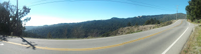
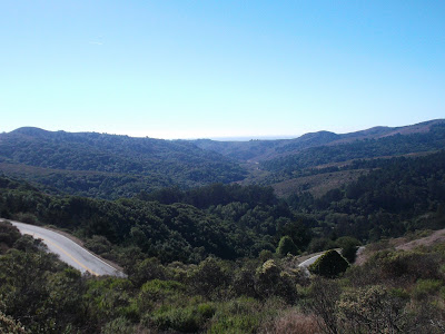
Panorama of the road and looking West.
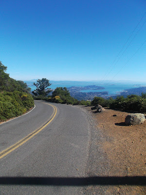
The ocean! I've been meaning to reacquaint myself with you.


Then Tam played her trick, the road veered up, and up I went. I pushed through it. I kept my cadence, stopped for many a pictures at the incredible views and before I knew it, it was West Peak. I didn't actually make it to the West Peak, but the road winds around West Peak, and drops before rising to Central peak, before dropping then rising one last, and tough time, to the East Peak, the highest peak. I'm not a fan of these drop and gain climbs (the Big Horns were infamous for this, making 8,000+ feel like 10,000+), but I got some good velocity into those series of climbs and eventually made it to the "summit".

A downhill? But I'm climbing!

I quote it like that because unfortunately, the road doesn't go all the way up. The firetower looms down over the visitor center, picnic area, and parking lot at a .3 mile hike up. I of course didn't bring my lock and fearing that Chicago moment (where I got my bike stolen), I decided this was good enough. Looked out, saw San Francisco, Oakland, Sausalito, the pine forests that cover the hills between, and tried to squint to see way off to San Jose, which is apparently visible on extremely clear days.

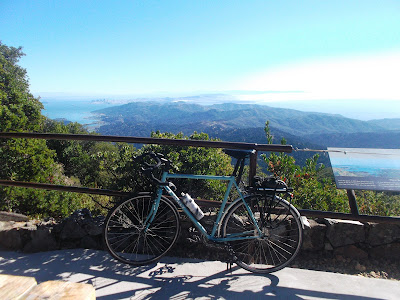
Surly on the summit, always looks good.
My bike matches the ocean, sorta.
And East, it's amazing how ugly East looks, so much brown!


At the summit some mountain bikes were kicking around. That's a tough way up, but got to be a fun way down. On my way down I peaked over to the fire road that carries those fat tires up, where a lycra'd out mountain biker was descending hard (and since when do mountain bikers where tight lycra?). Soon enough that will be me. If you're not familiar with Marin County, it, along with Boulder, CO, is the co-founder of mountain biking, and apparently harbors some of the best single track, so I'll have to get back out here.

On the descent it wasn't long before my Continental tire popped, again, there's another reason to get excited for those 40mm Schwalbes. I changed it quickly then bombed the descent. The descent was a good one, but not a great one. The beginning I found myself slamming the breaks a great deal, which isn't ideal on the downhill, it did eventually shallow out for some fun bends, but once those came I was nearly done. I passed cars on the left (something I'm hesitant about always, but hell, they always pass me when they shouldn't!) and took Highway 1 back out to Sausalito.

Back in San Francisco County.
Looking out beyond the bridge at the Golden Gate.
My buddies Sean and Christy on tour took beautiful photos from on top of that hill.
I need to get there sometime. 
I popped back over into SF, after hazardously avoiding tourists on the bridge, then had to climb more. By this point I was into my 60th mile and was shot, luckily I crossed quickly into the Mission, got my clips I needed to pick up and some Four Barrel Coffee, feeling yet another accomplished ride done. Now I need to find what the next "have to" ride is. Maybe Diablo without pavement? Maybe Mount Hamilton? Maybe an Oakland, San Francisco loop? Who knows!

Four Barrel Love.
Tam, you were tough, but I won.
For higher quality photos, plus some extras not posted go to my Flickr.

Friday, October 26, 2012

Getting High

Finally a good panoramic from the hills. 

My seasonal job is up, or at least I think.All this free time means lots of riding time! I haven't done any real long rides in these lazy days, but I have hit almost every road that goes over the Hills in the Oakland and Berkeley area.

Looking East from Tilden

While riding the other day a fellow rider mentioned to me a road in Tilden that closes every winter. Of course this meant I had to go find it. Finding South Park Drive I can totally understand why it closes every winter. The road is a 10 % grade reaching to the top of Grizzly Peak Boulevard, giving the most fantastic view of the Bay Area. I dropped down Claremont Ave, which is also a 10 % grade, so of course I had to come back and go back up it the next day.

Straight up South Park
I thought this was at the end of it. 
Then I had this. It always looks less steep in photos.

The view from the top of Grizzly Peak.

But why? Why constantly shred my legs going straight up the hills, when roads like Old Tunnel Road have a much gentler climb? Being here in Oakland I have for the first time lived near climbs. I wasn't much of a rider in my days on Long Island, but the highest point on Long Island is Bald Hill, a whopping 331 ft above sea level. Then in Buffalo it was a 30 mile ride to the Boston Hills to see any sort of elevation gain, and yeah, there were some absolutely brutal roads, but nothing that you could hit right off the bat.

Wild Cat Canyon Rd. A great climb going back West. Gentle and quick.
Looking East from Wildcat Canyon Rd.
From Claremont Ave, I like the way the city is boxed in by the Hills.

Now, here in Oakland, I leave my house and I'm in the hills. Doing a 30 mile ride, I can shred my legs, which may sound unpleasant to the non-athletes, but to anyone who enjoys the sport of pushing your physical limits may get this notion. I don't know the pure science behind it, but pushing your body to it's limits can create euphoric moments and literally cresting hills only amplifies these ecstasies.
(Mapmyride profile example: http://www.mapmyride.com/routes/view/148729613)

More of the Eastern hills.
Looking out at the Bay.
Claremont looking at the Hills.
Lost my fender, which means I can enjoy watching my tire spin on the descent.
There were lots of ravens out after the fresh rains.
These signs are dotted everywhere in the hills.
A fellow cyclist descending. He stopped for pictures too. He also had a beautiful Serotta.
Shephards Canyon Rails to Trails, flat between the Broadway climb and the Skyline climb.

Yesterday I found a hill on the backside through a nice little part of Orinda built on the hill side with gradients about as bruising as South Park Drive, so that's where I'm off to next.

There were some ranches on the top of the hills on the Orinda side, strange, but what a decent!
"Path of the Sky", not really, but close.
Orinda orchards.

Sunday, October 21, 2012

Roads I Love; Oakland, CA.

I feel like I haven't worked in weeks, but it's only been about three days. That plus being new to a city with not much to do, means I've had plenty of time to read, write, and of course ride! The reading has been mostly the celebrated travelogue Blue Highways by William Least Heat Moon. This has been a bad idea. Reading travelogues just inspires me to see more! The last part I've read through was the Southwest, which combined with my previous readings of Wallace Stegner and Edward Abbey, has me real inspired to get out into the open desert. Then before that it was his writings on the mysterious Creole country of Louisiana, which Henry Miller also expounded upon in An Air-Conditioned Nightmare. These readings are just more of a reason to get back on the road and see something new.


But besides the reading and my getting antsy, the riding has been great, I've even gotten a good sense of those hills to leave the GPS at home and actually know where I am going. That being said here is a short list of roads that I've learned to love so far in the Oakland Hills.

1. Skyline Boulevard
Surly looks sexy this high. View from Skyline.
This is the road I usually need to take to get to the other beautiful roads. It is a roadie highway it seems, as lycra'd speedsters zoom by, some with friendly smiles, other with brutal seriousness (must ride faster or you will think less of me). This road follows the crest of the mountain for the most part before Grizzly Peak bears (no bun intended) off towards a higher peak. Along this ridge you can look down over the populated cities of Oakland, Berkeley, and across the Bay at San Francisco or you can turn your head and look down on the water that quenches these peoples in the San Leandro Reservoir.
Misty Skyline.

2. Old Tunnel Road
Old Tunnel via Google Maps, look at the twists!

So far, my favorite way to descend the hills. A windy twisty drop down from the Northern end of Skyline Boulevard letting out right at Lake Temescal Regional Park. Being in the hills, it too has a handful of cyclists I pass on my way down (the ride up probably isn't too bad, the road seems fairly shallow on Old Tunnel). From the beginning you can look down the valley where Oakland rests, unfortunately listening to the blaring traffic of 24. The lack of cars on this road also means I get a chance to take the full road for those twists.
The top of Old Tunnel Road, looking over the noisy Highway

3. Pinehurst Rd
Pinehurst Rd via Google Maps

I love that sign. The north entrance to Pinehurst.

Looking East from the middle hill of Pinehurst.
Another view East, only with the Reservoir.
Arching around the backside of the hills, Pinehurst is the best way to loop Skyline. Connecting to Redwood Rd, Pinehurst bends and arcs near the Reservoir and passes through my favorite little spot Canyon, CA. Riding here mostly in the afternoon thus far, the trees provide excellent shade and the fog is usually non-existent thanks to the hills. The climbs are not super tough, but there is elevation to be gained here, and fun ones too, also with those twists and turns, including some wicked switchbacks and a Stop sign where only one car could pass (but about 8 cyclists, silly cars).
Pinehurst Elev Profile from Mapmyride.com
Awesome Fire house on Redwood Rd.
This must be why they call it Redwood Road.
These are only the beginning of my fun in the Hills, I hope to get Wildcat Canyon Road again, as I've taken that up over the backside of the hills before, and San Pablo Dam Rd, seems like a great way to make another loop. That being said I've been envious of the people on their offroaders playing around in the East Bay Ridge Trail, that means I'll have to get some knobbys soon and play too!